中華民國地圖學會 理事 許哲明 編寫
《東印度東部海圖-錫蘭島至中國廈門(A chart of the easternmost part of the East Indies from the island Zeloan to Amoy in China)》有兩種發行版本,其上標註的”Scarbrough shoal”(歐美人稱「斯卡伯勒灘」,1947年國民政府命名為「民主礁」,1983年中共定名為「黃岩島」),係祖國(英格蘭)地名移植而來,還是因船難船名而命名的呢?
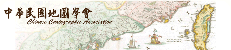
版本一,澳大利亞國家圖書館歷史地圖數位典藏,1671年John Seller (1630 -1698)製作發行之圖(如圖一),相關圖資:
■標 題:A chart of the eastermost part of the East Indies from the island Zeloan to Amoy in China [cartographic material] : with the adjacent islands adjusted according to the most accurate astronomical observations / [John Seller].
■比例尺:ca. 1/85,000,000
■出 版:London/s.n.,1671
■標 註:Map of the East Indies showing the coast of India, Malaysia, Philippines and the Indonesian archipelago. The top of Australia is shown as the Southern Land.
From v. III of : The English pilot/John Seller. London, 1671.
■引 自:Shirley, R. Maps in the atlases of the British Library, M.SELL-1.
圖一 《東印度東部海圖-錫蘭島至中國廈門》(Seller, 1671) 澳圖館典藏
John Seller (1630-1698)是英國十七世紀著名的地圖出版商,本身是測量員(surveyor)、製圖家(cartographer)、藝術家(artist)和皇家海道測量員(King's Hydrographer,1671年查爾斯二世任命);終其一生繪製發行的地圖、海圖、地圖集等相當的多。他於1671年發行的《英國航行員-第三冊-東方導航版(The English pilot, the third book; the Oriental Navigation)》中收錄有《A chart of the easternmost part of the East Indies from the island Zeloan to Amoy in China》這幅海圖,在中沙群島海域處標註有”Macclesfield Shoal”(現中沙群島)、”B. of Marsingola or the Scarbrough shoal” (現黃岩島)。
”Macclesfield”是十三世紀時已出現在英格蘭西北方的城鎮名,而英國皇家船艦(HMS)船艦或東印度公司(EIC)商船,並沒有以此為船名。
”Scarborough”是位於英格蘭北海沿岸一中世紀港口名,十三世紀時已是很活耀的市集;英國東印度公司(EIC) 有三艘船艦分別於1737年、1740年及1782年等曾以此命名之。
依年序來判斷,顯然當年在南海海域調查島礁時,就採用祖國(英格蘭)著名港口或城鎮地名來命名了,是有國土擴充移植之意識作為,這在早年海權強國殖民拓展時期是常有之現象。
版本二,Barry Lawrence Ruderman Antique Maps INC.古地圖數位典藏,也有一幅與Seller圖(版本一)完全相同的地圖,唯其製圖者(William Herbert /1718 -1795)與發行時間(1758)和其不同,此稱Herbert圖(如圖二):
標 題: A Chart of the Eastermost Part of the East Indies from the Island of Zeloan to Amoy in China with the adjacent Islands Adjusted according to the most accurate Astronomical Observations
製圖者:William Herbert
出 版:London / 1758
描 述:■Fine example of this rare English Sea Chart of Southeast Asia, the Philippines and contigous regions, from the first edition of Herbertr's A New Directory for the East Indies.
■Prepared in the style of a Portolan Sea Chart, Herberts chart covers the coasts of India, Malaysia, Philippines and the Indonesian archipelago. The top of Australia is shown as the Southern Land.
■The lack of knowledge in the region is evidenced by the many incomplete southern and western coastlines in New Guinea and the islands to the south.
參考文獻:Shirley, R. Maps in the atlases of the British Library, M.SELL-1c
圖二 《東印度東部海圖-錫蘭島至中國廈門》(Herbert, 1758) Barry典藏
William Herbert(1718-1795),英國書誌學家(bibliographer),於1758年出版《A New Directory for the East Indies》一書中收錄此幅《A chart of the easternmost part of the East Indies from the island Zeloan to Amoy in China》。國立臺灣歷史博物館典藏網〈看見台灣歷史〉中,就有這幅地圖,其基本圖資說明就是如前述。
Herbert於1758年繪製有一幅《A correct chart of the China Seas》(如圖三),圖內黃岩島處有註記”The Bank of Marsingla on which the Scarborough was aground 1748”;即是同一年份Herbert圖認定係因「英國Scarborough號航船擱淺(1748年)於此處」而命名的,故註記為”B. of Marsingola or the Scarbrough shoal”。唯最早一艘Scarborough號是1737年初航,很巧1748年時在Scarborough灘(亦稱Marsingola堆)擱淺了。
本文中Seller圖(1671年)與Herbert圖(1758年)是同一幅海圖,只是不同發行者在不同時間發行而已。依時序判讀,Seller圖係1671年發行的,已標誌此礁名為” Scarborough” ,這與「航行船艦」並沒有關聯性,而係祖國(英格蘭)地名移植之來源成分較高。
圖三 《中國海精確海圖》(Herbert, 1758) 澳圖館典藏 |