中華民國地圖學會 理事 許哲明
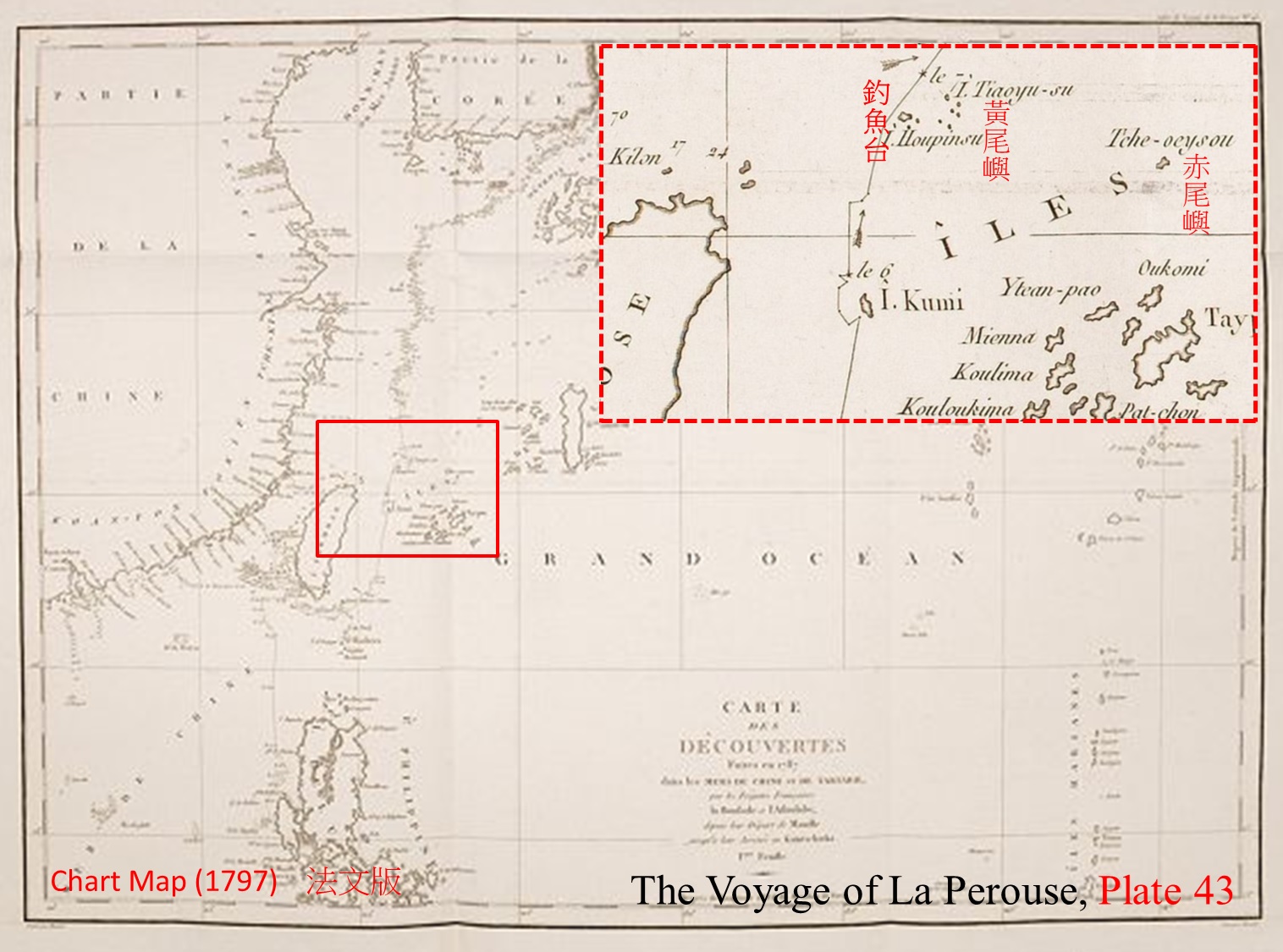
La Perouse爵士(1741 – 1788)是法國海軍探險隊軍官,在其環球探險航海歷程中,於1787年來到東北亞,相關的航海資料和繪圖,及時被送回法國。他雖在1788年間船難身亡了,直到1797年他所有書函及圖資等才被編輯出版《The Voyage of La Perouse》一書,1798年也發行英文版(London /printed for John Stockdale)。本文主題有關的,是其Plate 43及Plate 45的兩幅圖:
1. “Chart of Discoveries made in 1787 In the Seas of China and Tartary between Manilla and Avateha” (1799) Atlas du Voyage de la Perouse no. 43.
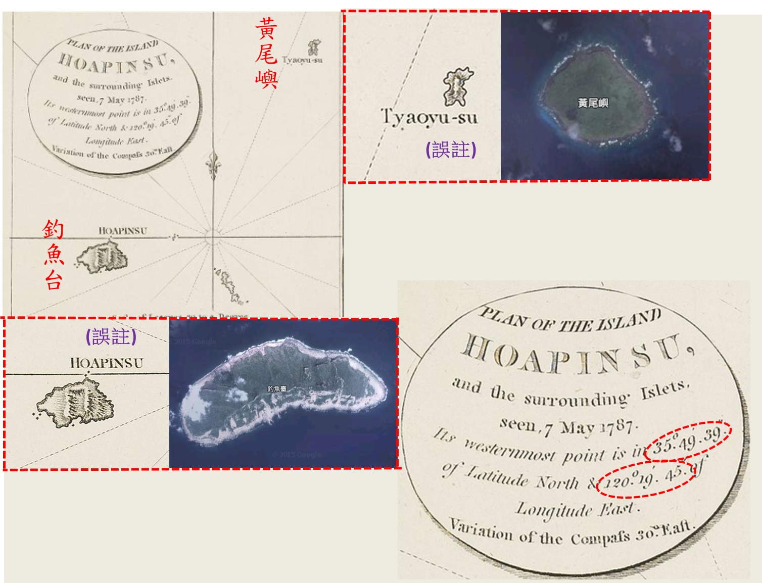
2. “Plan of the Island Hoapin su, and the surrounding Islets” (1797) Atlas du Voyage de la Perouse no. 45.
這兩幅圖( Plate 43和Plate 45)中均有標註”Tiaoyu-su”「釣魚台」。唯把最大島「釣魚台」錯註為”I. Hoapinsu”(花瓶嶼);把「黃尾嶼」錯註為” I. Tiaoyu-su”(釣魚台);赤尾嶼” Tche-oey sou”(僅Plate 43),拼寫略異,而” ou”與” u”音同。
Plate 45圖中共有五幅小島圖,圖中載錄"看到了"( "vue"法文,等同英文的"seen")的日期,並註明測繪之地理坐標(經度依巴黎本初子午線):
¬"a part of the isle of Quelpaert " ,on 21st May 1787,[33° 7' 49" N, 123° 58' 42" E]。現今韓國的「濟州島」。
¬"the isle of Hoapinsu",on 7th May 1787,[25° 49' 39" N, 120° 19' 45" E]。現今我國的「釣魚台」。
¬ “the isle of Dagelet”, on 27th May 1787,[27° 22' 18" N, 128° 58' 18" E]。現今韓國的「鬱陵島」。
¬"a part of the isle of Botol", on 3rd May 1787,[21° 58' 38" N, 119° 7' 25" E]。現今我國的「蘭嶼」。
¬"the isle of Kumi", on 5th May 1787,[24° 55' 15" N, 120° 20' 28" E]。現今日本冲繩的「與那國島」。
其中也只有第二幅島名有標註” HOAPINSU”及” Tiaoyu-su”,應該有參考到Gaubil圖(1752),這僅依相關圖資而編繪的,但1787年的這幅則是實地測繪的,只可惜島名誤註了。這幅註明測定的地理坐標是[25° 49' 39" N, 120° 19' 45" E],其本初子午線是巴黎,經度值換算為格林威治是[122° 39' 59" E],對照現值,偏西約49';這幅算是「釣魚台」已知最早的實地測繪值,是很有意義的一幅釣魚台地圖。
|